
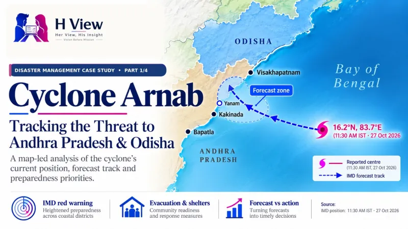
Cyclone Arnab Case Study: Before Landfall (Part 1)
A student-friendly disaster-management case study of Cyclone Arnab’s pre-landfall warnings, government preparedness and a clear framework for checking outcomes after the storm.
Case-study snapshot: 27 October 2026. Evidence cutoff: official bulletins cited here were issued by 2:30 p.m. IST. IMD National Bulletin No. 19, issued at 2:30 p.m., reported the storm’s centre at 11:30 a.m. IST. This is a dated pre-landfall study, not a live weather alert or final impact report. The cyclone had not made landfall in the evidence reviewed for this snapshot, so damage, casualties, rescue outcomes and recovery performance remain unconfirmed.
For students, the central management question is straightforward: how did a changing weather forecast become decisions about warnings, evacuation, shelters and essential services? The answer must be built from dated evidence, because the storm’s position and forecast can change while agencies are acting. This first instalment records the warning and preparedness phase; later parts will compare forecasts with observed impacts and recovery.
Case snapshot: what was known before landfall?
IMD Bulletin No. 19 reported that the very severe cyclonic storm was centred at 16.2°N, 83.7°E at 11:30 a.m. IST on 27 October, over the west-central Bay of Bengal. That placed it offshore, south-southeast of Visakhapatnam and east-southeast of Kakinada. IMD forecast that it would continue west-northwest and then turn northwest, crossing the Andhra Pradesh–Yanam coast between Bapatla and Visakhapatnam, close to Yanam, by the forenoon of 28 October.
The forecast is a planning signal, not a promise of an exact landfall point or wind speed. IMD Regional Meteorological Centre Kolkata’s Special Bulletin No. 10, issued at 1:30 p.m., forecast sustained winds of 125–135 kilometres per hour, gusting to 150 kilometres per hour, for the coastal crossing. This is one dated forecast; officials and residents should use the newest location-specific bulletin and district instructions because the track, timing and intensity can change.
Mind map: how to read the case
Read from forecast to decisions, then return after landfall to test each claim against observed evidence.
- Hazard information: storm position, movement, wind, rainfall, sea condition and surge forecast.
- Preparedness decisions:
- warnings and public communication;
- evacuation routes, transport and shelters;
- fishermen, boats, ports and coastal activity;
- health facilities, response teams and essential services.
- Evidence after the event: measured weather, affected people, damage, rescue, relief and restoration time.
- Learning: what the forecast enabled, who was reached, where gaps remained and what should change next time.
Forecast timeline: from alert to action
The 28 October entry is a forecast window from the 27 October bulletin, not a confirmed landfall observation.
A cyclone case study should preserve the order in which information arrived. Forecasts are revised as new observations and model guidance become available, so students should not combine values from different bulletins into a single imaginary forecast. The timeline below separates the warning, the reported position and the expected coastal crossing.
| Time | Official information or action | How to interpret it |
|---|---|---|
| 26 October | The National Crisis Management Committee reviewed preparedness. Central and state agencies reported shelter and evacuation arrangements, activated district control rooms, staged response teams and warned fishermen. | These are preparations reported by authorities; each district’s completion and coverage still need checking. |
| 27 October, 11:30 a.m. IST | IMD Bulletin No. 19 placed the cyclone centre at 16.2°N, 83.7°E over the west-central Bay of Bengal. | This is the reported centre at that observation time, not a live position for later hours. |
| 27 October, 1:30 p.m. IST | IMD RMC Kolkata Special Bulletin No. 10 forecast crossing winds of 125–135 km/h, gusting to 150 km/h. | This intensity estimate belongs to that bulletin and issue time. |
| 27 October, 2:30 p.m. IST | IMD National Bulletin No. 19 reported the 11:30 a.m. storm position and forecast a northwestward approach toward the Andhra Pradesh–Yanam coast. | The position is time-stamped; the forecast track and crossing area are estimates, not observed landfall. |
| Forenoon, 28 October | The forecast crossing window was between Bapatla and Visakhapatnam, close to Yanam. | Only post-event observations can establish where and when the storm actually crossed. |
 Also readMinistry of Panchayati Raj: What It Does and Why It Matters for Every Village→
What hazards did the forecast identify?
Tap to see how to read these ranges
A range belongs to a named bulletin and time. Keep the Visakhapatnam and RSMC surge estimates on separate rows, then compare both with measured water levels after the event; never combine them into one value.
Wind is only one part of a cyclone’s risk. Rainfall can trigger river, urban and flash flooding, while storm surge can push seawater into low-lying coastal areas; rough seas also threaten fishing crews and vessels. Preparedness therefore needs to match the hazard to the people and services exposed, rather than relying on the storm category alone.
| Hazard | What the official bulletins said | What the follow-up must verify |
|---|---|---|
| Wind | IMD RMC Kolkata Special Bulletin No. 10 (1:30 p.m. IST) forecast 125–135 km/h, gusting to 150 km/h, for the crossing. | Recorded wind speeds, location, time and instrument source. |
| Rain | IMD warned of very heavy to extremely heavy rainfall at isolated places in parts of coastal Andhra Pradesh and nearby areas. | Rain gauge totals, duration, flooding, landslides and affected communities. |
| Storm surge | The Visakhapatnam local bulletin and the RSMC technical advisory gave different ranges: 1.0–2.0 metres and 1.5–2.5 metres above astronomical tide, respectively. | Observed water levels and inundation, with the bulletin’s place, issue time and method recorded. Do not average the two forecasts. |
| Sea conditions | Phenomenal conditions were forecast in the west-central Bay of Bengal until landfall, with very high to phenomenal conditions along parts of the Andhra coast. | Observed sea state, boat safety, port operations and coastal damage. |
The difference between surge ranges is itself useful for students: bulletins may be issued at different times or for different operational areas. A careful analyst records the source and valid period beside each figure, then compares each forecast with observations rather than selecting whichever number looks most dramatic. Residents should follow current local alerts, not use this educational comparison as safety guidance.
Preparedness: what governments said they were doing
At the 26 October National Crisis Management Committee review, the Cabinet Secretariat said state and central agencies had made shelter and evacuation arrangements, activated district control rooms and placed National Disaster Response Force and State Disaster Response Force teams on standby. The Indian Coast Guard had helped guide vessels toward jetties or shore, while remaining ships were alerted to return. Fishermen were advised not to venture into affected sea areas, and response resources from the armed forces and other agencies were kept ready.
Odisha’s government also announced measures for vulnerable residents and essential services. Its preparedness review included moving people from low-lying areas where needed, arranging safer facilities for pregnant women and patients, preparing shelters and health services, and planning to restore roads, electricity and drinking water. Such announcements show the intended operating plan; the later review must establish which actions happened, when they happened and who was reached.
Andhra Pradesh reported evacuations and shelter readiness as the threat approached. Counts reported during an unfolding emergency are time-sensitive, and different agencies may count people moved, shelter occupants or households differently. For a student project, record every figure with its issuing agency, district, time and definition instead of treating a news snapshot as the final total.
Preparedness chain
IMD observation and forecast → state risk review → district alert and evacuation decisions → transport and shelter support → response teams and essential-service protection → post-landfall rescue, relief and restoration. Each arrow represents a hand-off where information, responsibility or resources can be delayed, misunderstood or lost.
How students can evaluate the response fairly
Tap for a quick student check
If a report says a shelter was prepared, ask where it was, who could reach it, how many people used it and what support residents received. Those questions connect a reported input to a measurable result.
Separate inputs, actions and outcomes. A shelter, a response team or a stocked health centre is an input; an evacuation or public warning is an action; safer people, functioning services and reduced losses are outcomes. Counting inputs helps describe readiness, but it cannot prove that people were protected or that the response worked.
| Stage | Evidence to collect | Questions for analysis |
|---|---|---|
| Inputs | Shelter capacity, transport, staff, supplies, communications and backup power. | Were resources placed near the highest-risk areas and accessible to people who needed assistance? |
| Actions | Alert times, evacuation orders, people moved, boat returns, shelter opening and rescue deployment. | Did action begin early enough, and were instructions clear in local languages? |
| Outputs | People safely housed, warnings delivered, roads cleared and medical teams operating. | Can the figures be independently checked and compared across districts? |
| Outcomes | Casualties, injuries, displacement, damage and time to restore power, water, roads and communications. | What changed for residents, and which outcomes can reasonably be linked to preparedness? |
Forecast versus event: the table to complete after landfall
This first article leaves the outcome column open on purpose. Once the cyclone passes, students should compare each forecast with measurements and official situation reports, preserving the forecast’s issue time and location. If the final track differs from the forecast, that does not by itself prove that the forecast or response failed; the decision question is whether agencies updated plans as evidence changed.
| Measure | Pre-landfall record | Post-event evidence to add |
|---|---|---|
| Track and landfall | Forecast crossing area: between Bapatla and Visakhapatnam, near Yanam; forecast forenoon 28 October. | IMD best track, actual crossing time and location. |
| Weather | Wind, rainfall, sea and surge risks listed above. | Measured winds, rain totals, observed surge and inundation maps. |
| People | Evacuation and shelter preparations announced. | People moved, shelter occupancy, unmet needs, injuries and displacement. |
| Services | Agencies planned for emergency response and restoration. | Power, water, roads, health services and communications restored by time and district. |
Student discussion: five questions to investigate
- How much lead time separated the first useful warning from the forecast impact, and how did the forecast change?
- Which groups could face barriers to evacuation, including older people, people with disabilities, patients, pregnant women, children and fishing communities?
- Did residents receive messages they could understand and act on, or can authorities report only that messages were sent?
- How did agencies coordinate shelter, transport, health, power, water and communications planning?
- Which data would be needed before calling the response effective, and who is responsible for publishing those data?
For digital-marketing students, the case also offers a lesson in crisis communication: reach is not the same as comprehension. A count of messages sent cannot show whether a resident understood the risk, trusted the source, knew where to go or could get there. A later audit should examine timing, language, accessibility, consistency across agencies and evidence of action.
Her View
Preparedness is experienced at household level, not on a control-room chart. A shelter matters when a family knows where it is, can reach it safely and finds the support needed for medicines, children, older relatives or disability access. The post-event review should therefore listen to residents as well as count infrastructure.
 Also readCBSE Board Exams 2027: Registration, Date Sheet Updates and What Students Should Check→
His Insight
For managers, this is coordination under uncertainty. Forecasts change, so a plan needs clear decision triggers, named responsibilities, backup resources and communication channels that still work during power or network failures. The quality of the plan is tested by how quickly teams can adjust without losing accountability.
What comes next in this case-study series?
Part 1 documents warnings and preparedness before landfall. Part 2 will compare the forecast with the observed track and impacts; Part 3 will examine relief, service restoration and early recovery; and Part 4 will bring the evidence together into a student case analysis. A separate communication-focused article can then examine how public alerts reached people and supported action.
FAQs
Where was Cyclone Arnab in this case-study snapshot?
IMD Bulletin No. 19 reported the centre at 16.2°N, 83.7°E at 11:30 a.m. IST on 27 October 2026. That is a time-stamped observation, not a live position for later in the day. Readers should check the newest IMD and district bulletin for current conditions.
Where was the cyclone forecast to cross the coast?
IMD forecast a crossing between Bapatla and Visakhapatnam, close to Yanam, by the forenoon of 28 October. This was an expected area and time, not a confirmed outcome. Part 2 of the series should replace the forecast with the observed track and crossing record.
Can students already decide whether disaster management succeeded?
Not from preparedness announcements alone. A fair assessment needs evidence about who received warnings, who moved, shelter conditions, rescue needs, losses and service restoration. The conclusion should explain what the evidence supports and what remains uncertain.
Sources and evidence cutoff
- India Meteorological Department, National Bulletin No. 19, issued 27 October 2026 at 2:30 p.m. IST.
- IMD Regional Meteorological Centre Kolkata, Special Bulletin No. 10, 27 October 2026 at 1:30 p.m. IST.
- IMD Visakhapatnam, local press bulletin issued 27 October 2026.
- IMD RSMC, Tropical Cyclone Advisory No. 12, based on 0900 UTC, 27 October 2026.
- Cabinet Secretariat / Press Information Bureau, National Crisis Management Committee preparedness review, 26 October 2026.
- Government of Odisha, review of preparedness for the possible cyclone.
Editorial note: This version records the pre-landfall evidence available for the cited bulletin times. It does not report confirmed landfall, casualties, damage or recovery outcomes. Follow current IMD bulletins and local authority instructions for safety information.
H View stories follow our editorial policy. Spotted an error? Tell us and we will correct it.
Rate this article
One tap is enough. No comment needed.
Was this article helpful?
Your answer goes straight to our editors.








Comments0
No comments yet. Start the conversation.